Jeju, the 'Volcanic Island': Secret Behind Wolrabong's Growth Uncovered
- Input
- 2026-11-18 10:11:46
- Updated
- 2026-11-18 10:11:46
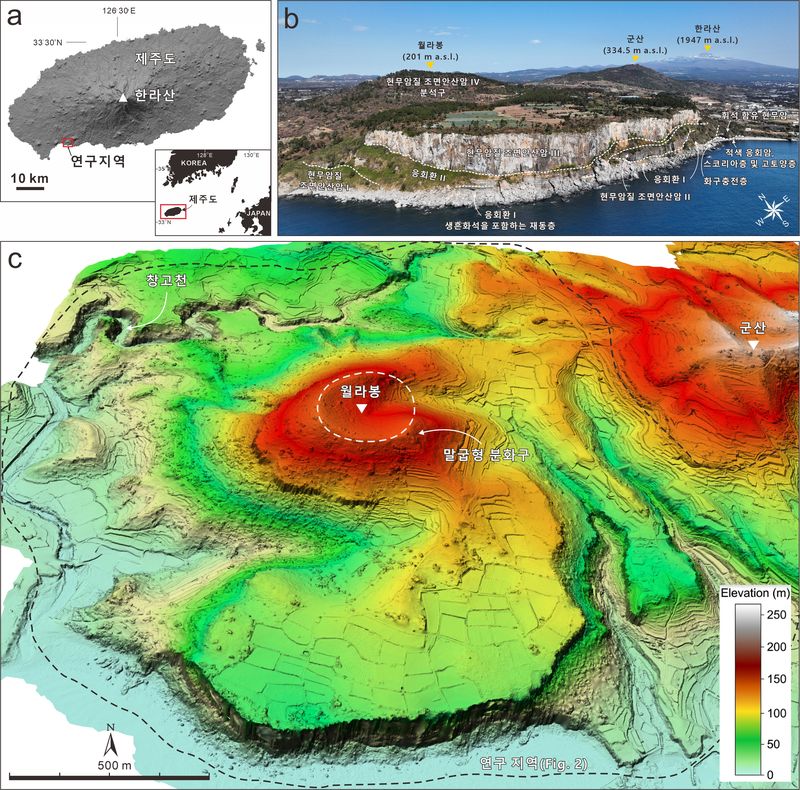
The early growth record of a volcanic island can easily be buried by lava and volcanic ash from later eruptions or eroded away by waves. Wolrabong, however, is an area where traces of Jeju's ancient volcanic activity are clearly exposed at the surface. Lava and volcanic deposits are continuously exposed along the coastal cliffs, making it possible to examine how the volcanic edifices grew.
The research team produced a detailed volcanic geological map at a scale of 1:5,000 and divided lava, volcanic ash layers, deposits redeposited by waves, ancient soil layers, and other materials into 10 stratigraphic units. They also combined the ages of volcanic rocks, the chemical compositions and microstructures of volcanic glass and lava, and drone-based topographic data to interpret the sequence in which the layers formed and the conditions at the time.
The analysis confirmed that the Wolrabong volcanic complex grew through three main stages.
Initially, volcanic activity formed volcanic edifices when sea levels were low. As sea levels subsequently rose, edifices formed at multiple vents were eroded by waves, and eruptive materials accumulated again; this process was repeated. In the final stage, eruptive materials filled the spaces between the edifices, and thick lava covered them, linking the separate edifices into one. The researchers determined that the lava protected the complex from wave erosion, allowing it to grow stably even at high sea levels.
The study also demonstrated the importance of detailed geological surveys. Rocks with similar chemical compositions appeared to come from the same eruption when examined through analysis alone. But when the researchers traced the boundaries between strata, their order of deposition, and their lateral continuity in the field, the rocks could be distinguished as records of eruptions from different periods. The team documented these observations on a geological map and linked them with analytical data to reconstruct the growth history of the volcanic edifices.
The findings can help explain Jeju's early volcanic activity and how volcanic islands grow in shallow waters, and can be used to assess the value of the geological heritage around Wolrabong and develop educational and interpretive content. The data accumulated through detailed surveys are expected to provide a foundation for integrating digital geological information and building 3D geological models in the future.
“The significance of this research is that, by connecting records preserved in the strata through a detailed geological map, we have revealed how small volcanic edifices withstood wave erosion and grew into a single island,” said Dr. Ko Seon-young. “We will continue to combine detailed geological surveys with a range of analytical data to shed light on how the land was formed and enhance the value of geological information for practical use.”
The findings were published on August 1 in Scientific Reports, an international journal in the Nature Portfolio.
[email protected] Yeon Ji-an Reporter