Low-altitude aviation weather app launched for air ambulances ... “Check conditions even when communications are down”
- Input
- 2026-11-11 15:38:21
- Updated
- 2026-11-11 15:38:21
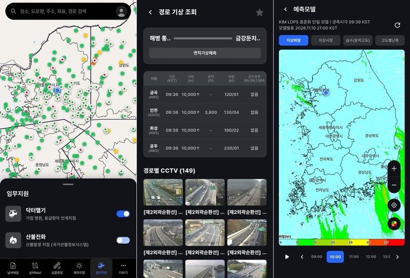
[Financial News] Pilots of medical helicopters and wildfire-fighting helicopters can now check weather and hazard information along their flight paths at a glance on their smartphones. The app is expected to help with urgent missions, including transporting emergency patients and fighting wildfires, as users can access weather information saved in advance even if communications are interrupted.
The Korea Meteorological Administration (KMA) said on the 11th that it would begin operating LAMIS-A, a mobile application (app) that supports the safe operation of low-altitude aircraft such as rescue and emergency medical helicopters, wildfire-fighting helicopters, light aircraft and drones, this month.
Because low-altitude aircraft fly close to the ground, they are vulnerable to sudden weather changes caused by terrain. When a rapid response is needed, particularly for missions such as transporting emergency patients or fighting wildfires, it is important to quickly assess weather conditions and decide whether to fly and which route to take.
The newly launched LAMIS-A is an adaptation of LAMIS-M, an existing web-based low-altitude aviation weather service, for mobile devices. By setting a departure point, waypoints and a destination, users can view three-dimensional forecast information along the flight path, including temperature, wind, clouds and turbulence at different altitudes. Weather risks are presented in four levels.
Users can also view weather radar, satellite imagery and real-time observations around the flight path, as well as closed-circuit television (CCTV) footage. Information needed for missions, including medical helicopter routes, emergency patient handover points and wildfire locations, is also shown on the map.
The app also has an offline storage feature for use in case of communications disruptions. It can be downloaded from the Google Play Store, the App Store and ONE store.
KMA chief Lee Mi-sun said, “Because low-altitude aviation is used for important missions that protect people’s lives and safety, including rescue and emergency response and wildfire suppression, aviation weather information that enables users to quickly check and assess rapidly changing weather conditions plays a very important role.” She added, “We will continue to develop the service by incorporating users’ feedback.”
[email protected] Lee Bomi Reporter