Your location and fishing-ground boundaries at a glance—even at sea: Incheon develops app for fishers
- Input
- 2026-11-04 09:09:40
- Updated
- 2026-11-04 09:09:40
【Financial News, Incheon = Han Gab-soo】 On land, people can easily check their location and information about nearby roads and buildings on a smartphone, but it is difficult to pinpoint one’s location at sea. As a result, fishers have faced considerable difficulties identifying on the spot which fishing ground their location falls within while working at sea, or whether they have entered a restricted fishing zone.
To address this gap in information at sea, Incheon City has introduced a mobile-based marine and fisheries information service for use in the field.
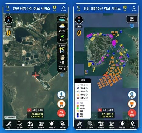
The Incheon Fisheries Resources Research Institute said on the 4th that it had developed an app called “Incheon Fisheries Information,” which allows fishers to check fishing-ground boundaries and fishing-related information in Incheon waters on their smartphones, and officially released it on Google Play.
A key feature of the app is that it brings scattered administrative information related to marine and fisheries affairs together on a map. Until now, information on licensed fishing grounds, fishing ports and artificial reefs, among other marine and fisheries-related topics, had been dispersed across documents such as registers, maps, Excel files and reports. Fishers had to search for the relevant materials separately to find the information they needed while working at sea.
In particular, unlike on land, it was difficult at sea to see fishing-ground boundaries or restricted fishing zones at a glance based on one’s location, prompting concerns that access to information was limited during fishing operations.
To address these problems, the city developed the app using VWorld, the Ministry of Land, Infrastructure and Transport’s spatial information platform. By using the existing platform without commissioning a separate project or building a server, it reduced development costs and administrative burdens.
As of October 2026, the app contains 26 types of marine and fisheries information, including 618 licensed fishing grounds in the Incheon area, as well as fishing ports, artificial reefs and spatial information related to fishing operations. It also allows users to check weather, tides and water temperature all on one screen.
Fishers can use the map on their smartphones while working at sea to compare their current location with fishing-ground boundaries. They can also check related information, including restricted fishing zones, which is expected to help reduce confusion when using fishing grounds.
Beyond simply showing a location, the app also provides weather and marine information needed to assess fishing conditions. Users can review weather, tides and water temperature together and use the information to plan when to head out to sea and how to fish.
The app also includes features to reduce administrative workloads. It allows fishers to fill out relevant documents, such as self-management activity logs, in the field, easing the inconvenience of having to use paper documents or separate materials.
The project is also significant because it did more than digitize administrative information: it turned that information into a service that can be used in actual fishing operations.
“Incheon Fisheries Information” received external recognition by winning the grand prize, the Minister of Land, Infrastructure and Transport Award, in the spatial-information use case category at the 8th Spatial Information Utilization and Ideas Contest, hosted by the Ministry of Land, Infrastructure and Transport and organized by the Spatial Information Industry Promotion Agency.
The city plans to continue improving the app’s features based on feedback from fishers in the field.
Kim Ik-jung, director-general of the city’s Agriculture, Fisheries and Food Bureau, said, “We will continue to improve the app’s features based on fishers’ feedback so they can easily check location-based marine and fisheries information in the field at sea, just as they can on land.”
[email protected] Han Gab-soo Reporter