Busan Port Authority (BPA) to offer global location tracking for vessels calling at Busan Port
- Input
- 2026-10-07 10:56:57
- Updated
- 2026-10-07 10:56:57
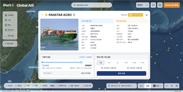
The BPA said on the 7th that it had introduced a global Automatic Identification System (AIS) to Port-i, expanding the range for tracking vessel locations from domestic coastal waters to waters around the world.
Port-i is a system that links and integrates operating data from all container terminals at Busan Port, allowing users to monitor the handling status of berths, vessels and cargo at a glance. The newly added global AIS features provide real-time location tracking for vessels calling at Busan Port, visualization on 2D flat maps and a 3D globe, and an integrated view of vessel locations and berth schedules at Busan Port.
Until now, Port-i has provided vessel location information for waters near Busan Port. With the introduction of global AIS, it is now possible to immediately check the location of any vessel with a history of calling at Busan Port, wherever it may be in the world.
Users can filter out and display on a map only the vessels worldwide that are bound for Busan Port, and view vessel locations and berth schedules together on one screen without having to visit multiple websites.
Users can also track vessel movements at major ports around the world and along key maritime routes and passages, including the Panama and Suez canals and the Strait of Hormuz. Additional features include registering vessels of interest, viewing track histories by period, checking call sequences by route, and looking up vessels scheduled to enter each port, allowing users to monitor operations by route and port.
“With the introduction of global AIS, Port-i’s view has expanded beyond Busan Port to the world’s oceans,” said BPA President Song Sang-geun. “As interest grows in new sea routes such as the Arctic route, we will continue listening to voices from the field and further develop Busan Port’s digital platform.”
[email protected] Kwon Byeong-seok Reporter