Korean Meteorological Administration Expands 'Weather Map' Worldwide, Offering a 3D View of Global Weather
- Input
- 2026-09-22 11:52:08
- Updated
- 2026-09-22 11:52:08
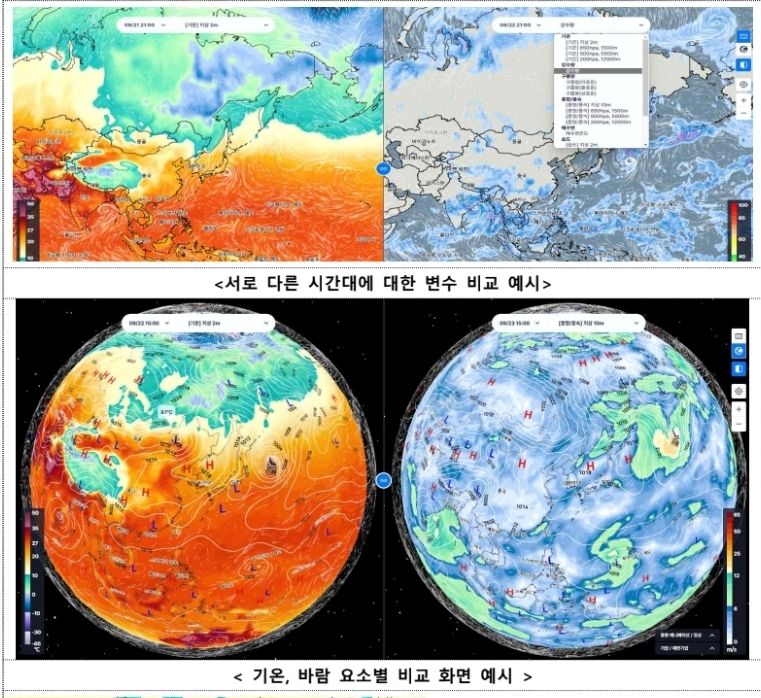
[Financial News] The Korean Meteorological Administration's 'Weather Map' service is expanding from a Korea-centered service to the entire world. Based on the Korean Integrated Model (KIM), it will allow users to view weather conditions across the globe on two-dimensional flat and three-dimensional spherical maps. Radar, satellite, and wind data will also be displayed together, allowing users to check the direction and speed of rain clouds.
The Korean Meteorological Administration made the revamped Weather Map service available through Nalssinuri and the Nalssi Allimi app starting on the 22nd.
The Korean Meteorological Administration has expanded the Weather Map's coverage, which had previously been limited to the area around the Korean Peninsula, to the entire world.
Alongside a two-dimensional flat map, a three-dimensional spherical map has been newly introduced, enabling users to view the Earth's atmospheric circulation in three dimensions. The KIM, developed in-house by the Korean Meteorological Administration, is used as the underlying data source.
From broad global weather patterns to detailed weather conditions in specific areas, users can see everything on one screen.
Users can search for a city to go directly to that location or click a desired point on the map to view changes over time in temperature, wind, and humidity.
The range of available weather information has also expanded. Through the KIM global model, users can view wind, temperature, and humidity at the surface and at 850 hPa, 500 hPa, and 200 hPa. The service also provides precipitation and cloud data, sea-surface temperatures, sea ice, and snowfall accumulation. Temperatures and feels-like temperatures from short-term forecasts, precipitation probabilities and amounts, weather alerts, and observational data such as radar and satellite imagery can also be viewed on the map.
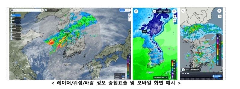
The feature for tracking the movement of rain clouds has also been improved. Existing radar images lost resolution when users zoomed in, but the application of vector-based radar has addressed the problem. Wind data is displayed over precipitation areas detected by radar, allowing users to determine the direction and speed at which precipitation bands are moving.
New features also allow users to overlay or compare multiple types of weather information. Weather charts by altitude can be superimposed on numerical model data, while satellite imagery can be overlaid on radar data with the satellite images serving as the background.
CCTV footage and road maps can be added to the forecast screen. Users can also compare weather conditions at different times or compare individual elements such as temperature and wind.
The way large volumes of weather data are processed has also been improved. A method that compresses and partitions multidimensional data before storing it has been adopted, increasing the speed at which high-resolution weather data appears on the map.
The revamped Weather Map is available through the Korean Meteorological Administration's Nalssinuri and Nalssi Allimi app. The Korean Meteorological Administration also plans to revamp the first screen of the Nalssi Allimi app around December.
Lee Mi-sun, commissioner of the Korean Meteorological Administration, said, "This next-generation Weather Map is the result of combining data from the Korean numerical model with advanced data-processing and visualization technologies, making it easier for the public to understand and accurately experience weather information." She added, "We will continue to expand weather services tailored to the public's needs."
[email protected] Lee Bo-mi Reporter