Typhoon Dujuan Unlikely to Affect the Korean Peninsula; Jeju Could See More Than 100 mm of Rain on the 18th [FN Weather]
- Input
- 2026-09-17 14:59:46
- Updated
- 2026-09-17 14:59:46
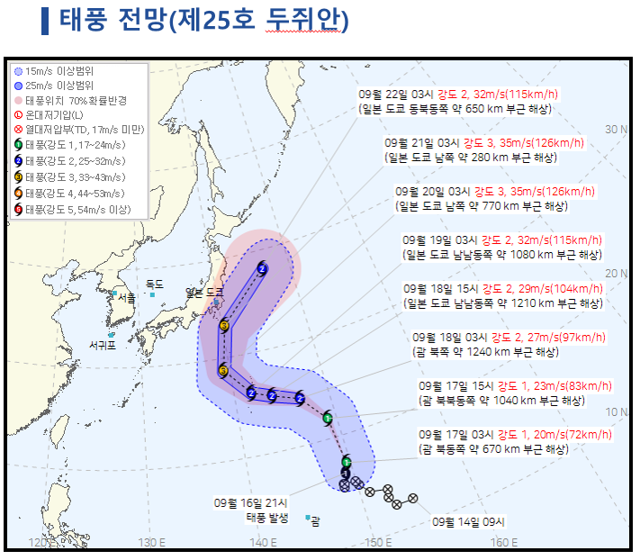
[Financial News] Typhoon No. 25 Dujuan is forecast to move away into waters east of Japan without affecting the Korean Peninsula. Cold air moving down from the north is blocking the typhoon's northward movement. However, as easterly winds strengthen around the 18th, some parts of Jeju Island could receive more than 100 mm of rain, and a heavy rain advisory could be issued.
The Korean Meteorological Administration said at a regular forecast briefing on the 17th, "Based on the current forecast, the typhoon is unlikely to affect our country." Dujuan is currently far offshore southeast of Japan and is expected to move north toward waters east of Japan. The agency explained that a high-pressure area accompanied by cold air has settled north of the Korean Peninsula, while the cold air is moving south and limiting the space through which the typhoon can advance toward the peninsula. The typhoon is expected to move east of Japan along the edge of the North Pacific High.
The Korean Meteorological Administration also assessed that the typhoon was unlikely to turn toward the Korean Peninsula even if its track changed somewhat.
A Korean Meteorological Administration official said, "The typhoon's track may change slightly as it moves north, but based on our current forecast, it is unlikely to turn toward our country."
The possibility of typhoons forming has not disappeared following this storm. The Korean Meteorological Administration explained that tropical disturbances, which can serve as the seeds of typhoons, continue to form over tropical waters to the south. It said people should continue monitoring typhoon activity through late September and early October.
The main factor affecting the Korean Peninsula's weather this week will be easterly winds rather than the typhoon. The pressure difference between the high-pressure system to the north and the low-pressure system to the south is expected to widen on the 18th, producing the strongest easterly winds.
The easterly winds will draw moisture in from the sea, and rain is expected in parts of the East Coast as the moist air encounters mountainous terrain. Rainfall totals are expected to remain limited.
The situation will be different on Jeju Island. Relatively cold air descending from the north is expected to meet warm, humid air from the south near the island, potentially leading to the development of bands of heavy rain clouds.
Jeju Island is expected to receive 20–60 mm of rain from the 17th through the 18th, with more than 100 mm in some areas. Rain will be concentrated around the 18th, and a heavy rain advisory could be issued.
However, the timing and amount of rainfall could vary depending on the strength of the easterly winds and the location of the boundary where the two air masses meet.
On the 19th, the high-pressure system over the East Sea will gradually move eastward, weakening the easterly winds. Rain along the East Coast and on Jeju Island will therefore gradually ease and is expected to stop in most areas by the afternoon. On the 20th, a migratory high-pressure system moving in from the northwest will expand, bringing generally clear skies to the west, while the East Coast and Jeju Island will see somewhat more cloud cover.
Strong winds and high waves will also require caution. As the pressure difference between the high-pressure system to the north and the low-pressure system to the south widens, strong winds are expected mainly along the East Coast and on Jeju Island. Inland and mountainous areas could also experience occasional gusts.
Very high waves are expected in the East Sea, South Sea, and waters around Jeju Island. The strong wind and high wave advisories currently in effect for the South Sea and waters around Jeju Island could remain in place through the weekend. Swells could reach the coasts of the East Sea, South Sea, and Jeju Island, so caution is needed near coastal areas such as breakwaters and rocky shores.
Daytime temperatures will rise to around 28–30°C, mainly in western and southern regions. Some western areas will be 2–3°C warmer than average and may feel somewhat hot during the day.
By contrast, temperatures will drop quickly in the morning and evening due to radiational cooling, falling to around 17°C in some inland areas. Many regions will see a difference of more than 10°C between daytime and nighttime temperatures. Along the East Coast, daytime temperatures will be lower than in the west because of the influence of easterly winds, clouds, and rain.
[email protected] Lee Bo-mi Reporter