Are the Kuril Islands Russian Territory? Japan Demands Corrections to New World Map
- Input
- 2026-09-10 15:00:23
- Updated
- 2026-09-10 15:00:23
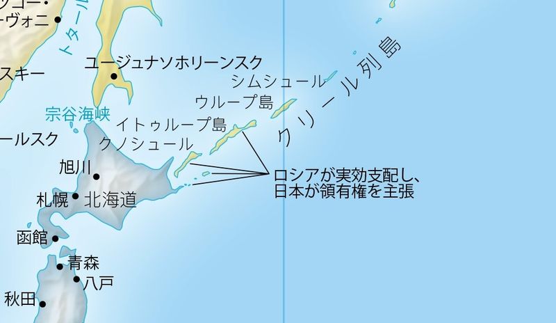
【Financial News Tokyo = Correspondent Hye-jin Seo】Japan has demanded corrections after four islands in the Kuril Islands, an area disputed by Japan and Russia, were shown in the same color as Russian territory on a new world map recommended for use by countries by the United Nations General Assembly. The issue has sparked controversy in Japan because Japan also voted in favor of the UN resolution recommending the map projection.
According to NHK and other outlets on the 10th, a map posted on the official website for the Equal Earth projection shows the four southernmost islands of the Kuril Islands, which Japan calls the "Northern Territories," in the same color as Russian territory. A note below the map states, "Russia exercises effective control, while Japan claims sovereignty."
Japan regards the four islands—Iturup, Kunashir, Shikotan Island, and the Habomai Islands—as its inherent territory and maintains that Russia illegally occupies them. As a result, concerns have been raised that the map’s depiction and accompanying explanation contradict the Japanese government’s official position.
Minoru Kihara, Japan’s Chief Cabinet Secretary, said at a press conference that day, "We are aware that a map released by the proponent of the Equal Earth projection contains a depiction that contradicts the Japanese government’s position."
He added, "To prevent misconceptions about Japanese territory and geographical names from spreading, we have asked the website operator through our overseas diplomatic missions to correct the depiction. We will continue to take the necessary measures to ensure that Japan’s position is not undermined."
Earlier, on the 4th, the United Nations General Assembly adopted a resolution recommending that national governments, educational institutions, international organizations, and technology companies promote and use the Equal Earth projection. A total of 164 countries, including Japan, voted in favor.
The Japanese government drew a distinction between its support for the resolution and the map in question. Kihara explained, "The UN resolution concerns the Equal Earth projection itself and is not directly related to any specific map created using this projection, including the content posted on the website."
Developed in 2018, the Equal Earth projection was designed to address the Mercator projection, which increasingly exaggerates the size of areas at higher latitudes. It more accurately represents the relative areas of countries while reducing distortion in the shapes of continents.
[email protected] Hye-jin Seo Reporter