Foreign low-orbit satellites combined with the Cheollian Satellite 2A to detect even 'small wildfires'
- Input
- 2026-09-10 14:54:11
- Updated
- 2026-09-10 14:54:11
[Financial News] The number of satellites used for wildfire monitoring will increase from one to eight. By adding seven overseas low-orbit satellites to the geostationary Cheollian Satellite 2A, it will be possible to detect small wildfires that were difficult to capture with existing satellites and even identify the 'fire line,' the boundary where a fire spreads.
The Korean Meteorological Administration announced that it will launch a pilot service for this "multi-satellite-based wildfire monitoring information" starting on the 10th. It will utilize seven additional low-orbit satellites from the United States and Europe in addition to the Cheollian Satellite 2A, which has been used for wildfire monitoring since July 2019.
The additional satellites include the U.S. Suomi National Polar-orbiting Partnership (S-NPP), NOAA-20 and NOAA-21, and Europe's Metop-B, MetOp-C, Sentinel-3A and Sentinel-3B. Of these, data from five satellites is received directly by the National Meteorological Satellite Center, while the remaining two are received through the European Meteorological Satellite Center.
The reason for adding low-orbit satellites is the difference in resolution. The spatial resolution of the Cheollian Satellite 2A is 2 km, with each pixel representing approximately 400 ha. Overseas low-orbit satellites have a resolution of 375 m to 1.1 km, allowing for the observation of about 14 to 121 ha per pixel. This represents a spatial resolution approximately 3 to 28 times higher than existing systems.
The Korean Meteorological Administration developed wildfire detection technology by overlaying and analyzing satellite data with different resolutions and observation times. While it was difficult to distinguish small wildfires using only the Cheollian Satellite 2A because their signals mixed with heat from the surrounding surface, utilizing high-resolution data from low-orbit satellites allows for clearer identification of wildfire signals.
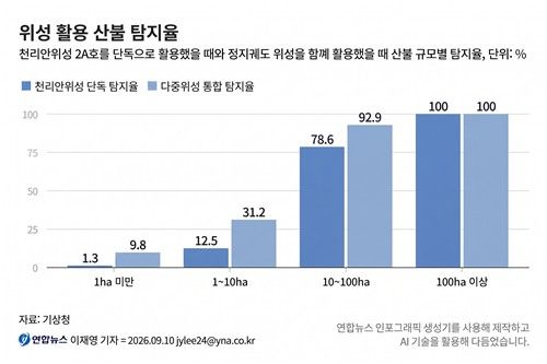
In a verification conducted on actual wildfires that occurred last year, the detection rate increased significantly. An analysis of 205 out of 317 wildfires in 2025 that occurred while low-orbit satellites were passing over the Korean Peninsula showed that the detection rate for wildfires smaller than 1 hectare rose from 1.3% when using the Cheollian Satellite 2A alone to 9.8% when utilizing multiple satellites. The detection rate for wildfires ranging from 1 to 10 hectares also increased from 12.5% to 31.2%.
By utilizing multiple satellites together, it is possible to identify not only whether a wildfire has occurred but also the 'fire line,' which is the boundary where the flames spread. The Cheollian Satellite 2A observes the Korean Peninsula at 2-minute intervals to track the occurrence and continuation of wildfires, while overseas low-orbit satellites capture the fire line with relatively high resolution as they pass over the Korean Peninsula.
Multi-satellite wildfire monitoring information is provided every hour on the National Meteorological Satellite Center website. Taking into account that the transit times of low-orbit satellites over the Korean Peninsula vary, wildfire results detected by each satellite over the past 12 hours are overlaid onto a single image.
In the video, detection points from 12 hours ago are marked in black, and as the time approaches the present, they are displayed in red. This allows one to see at a glance where the wildfire started and in which direction it spread.
"I hope that the collaboration between the Cheollian Satellite 2A, which monitors the area without rest, and overseas low-orbit satellites that detect even small fires whenever they pass over the Korean Peninsula will help ensure that the decisive moment to minimize wildfire damage is not missed," said Lee Mi-sun, head of the Korean Meteorological Administration.
[email protected] Lee Bo-mi Reporter