Typhoon Krovanh’s Center Is 500 km From Jeju, but Strong Winds and Ferry Controls Begin
- Input
- 2026-09-04 05:13:26
- Updated
- 2026-09-04 05:13:26
【Financial News Jeju—Reporter Yong-bok Jeong】 Although the center of Typhoon No. 24 Krovanh is passing through waters about 500 km from Jeju Province, strong winds and high waves have already begun affecting the island. Strong-wind and high-wave advisories that had been issued as preliminary notices the previous day were upgraded to official advisories, and some passenger-ferry services to the Chujado Islands, Gapado Island and Marado were suspended.
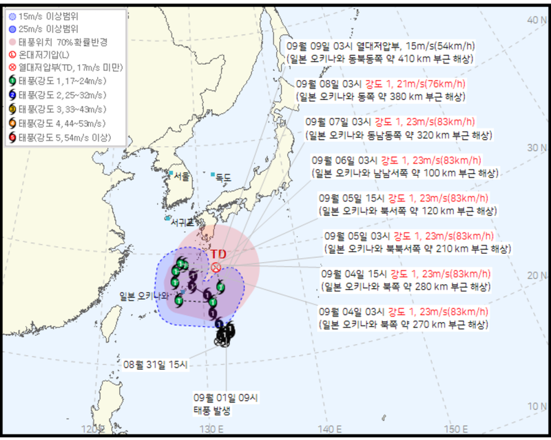
According to the Korean Meteorological Administration, at 3 a.m. that day, Krovanh was moving northwest at 34 km/h from waters at 29.0 degrees north latitude and 128.2 degrees east longitude, about 270 km north of Okinawa.
The typhoon had a central pressure of 992 hPa, maximum winds of 23 meters per second, or 83 km/h, and a radius of strong winds extending 250 km.
It was moving north faster than forecast the previous day.
In a forecast issued at 4 a.m. on the 3rd, the Korean Meteorological Administration had projected that the typhoon’s center would be at 28.6 degrees north latitude and 128.1 degrees east longitude at 3 a.m. on the 4th, moving at 18 km/h. The actual analysis placed the center at 29.0 degrees north, with a speed of 34 km/h.
However, the typhoon is not expected to continue north toward the Korean Peninsula. The Korean Meteorological Administration forecast that Krovanh would turn west-northwest at 3 p.m. that day over waters about 280 km northwest of Okinawa, while its speed would sharply decrease to 7 km/h.
It will move southwest on the morning of the 5th, then head south and south-southeast. From the 7th, it is expected to turn east again and weaken into a tropical depression on the 9th.
Strong winds and high waves reached Jeju Province before the typhoon’s center. The Korean Meteorological Administration issued a strong-wind advisory for all of Jeju Province and high-wave advisories for all surrounding waters.
Waves off eastern Jeju Province are expected to reach up to 5 meters. Waves of around 4 meters are forecast in the northern, western and southern coastal waters as well.
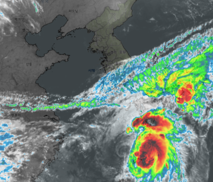
Images from Cheollian 2A also showed strongly developed cloud bands around Krovanh spread widely across the Okinawa area and the waters southeast of Jeju Province. Although the typhoon’s center is distant from Jeju Province, the island is also being affected by the surrounding pressure system and strong easterly winds.
The marine advisories led to disruptions in passenger-ferry services. According to operating information from the Korea Maritime Transportation Safety Authority, the Songrim Blue Ocean, which was scheduled to travel from Jeju through the Chujado Islands to Wando at 8 a.m. that day, was suspended because of deteriorating weather. Services on the Moseulpo–Gapado Island and Moseulpo–Sani Sudong–Marado routes were also scheduled to be suspended from their morning departures.
However, ferry services across Jeju Province have not been completely halted. The Hanil Gold Stella and Silver Cloud, large car ferries on the Jeju–Wando route, were classified as operating normally in early-morning service information. Because marine conditions are changing rapidly, passengers should check again immediately before departure to confirm whether the vessels will actually sail.
Attention is now turning to Jeju International Airport.
As of 5 a.m., it was too early to assess the scale of cancellations and delays caused by the typhoon because the day’s flight operations had not yet fully begun.
Flights are not automatically canceled simply because a strong-wind advisory has been issued for land areas. Operations are determined by considering the actual wind direction and speed at Jeju International Airport, the presence of wind shear, weather conditions at the departure and arrival airports, and the aircraft type.
However, strong easterly or northeasterly winds around Jeju International Airport’s runway can create wind shear and affect aircraft takeoffs and landings. Whether strong winds and wind shear will lead to actual flight disruptions from the morning, when the first departures and arrivals begin, will be the first major test for the day’s air traffic.
The situation involving Krovanh shows that regional impacts cannot be assessed solely by the typhoon’s projected center track. Based on the current forecast, the typhoon’s center is unlikely to pass directly over Jeju Province. Nevertheless, a strong-wind advisory is already in effect on land across Jeju Province, high-wave advisories have been issued for all surrounding waters, and ferry services to some outlying islands have been suspended.
Therefore, the impact on Jeju Province that day should be judged less by whether the typhoon makes landfall on the island than by actual peak wind speeds, wave heights at sea, wind shear at Jeju International Airport, flight cancellations and diversions, and any additional ferry suspensions.
In particular, it will be important to see whether Krovanh slows and turns west as forecast in the new typhoon information scheduled to be issued by the Korean Meteorological Administration at 10 a.m. that day. Since the storm had already moved faster than forecast the previous day during its northward movement, its subsequent position and speed will also need to be monitored continuously.
The Korean Meteorological Administration urged residents to take particular care with facilities and coastal safety, as strong winds are expected across Jeju Province and high waves and swells will continue at sea.
[email protected] Yong-bok Jeong Reporter