Temperatures Soared to 42.5°C, Then Came a Deluge: Why This Summer’s Weather Swung from One Extreme to the Other
- Input
- 2026-09-03 17:22:53
- Updated
- 2026-09-03 17:22:53
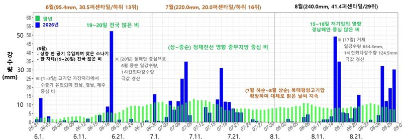
[Financial News] This summer’s weather swung from one extreme to the other. On August 2, the daytime temperature in Yangsan, South Gyeongsang Province, soared to 42.5°C. From August 15 to 18, Geoje received 968.1 millimeters of rain over four days. Although total summer rainfall was only 76% of the average, some areas received within days an amount equivalent to half their normal annual precipitation.
The Korean Meteorological Administration analyzed that this summer was marked by pronounced climate variability and regional polarization. Heat waves, drought and heavy rain occurred one after another within a short period, while different regions experienced contrasting extreme weather events at the same time.
Third-highest average temperature on record: Late-starting heat waves were exceptionally intense
According to the Korean Meteorological Administration’s report on the climate characteristics of summer 2026, the nationwide average temperature from June through August was 25.4°C, 1.7°C above normal. Since records began in 1973, this was the third-highest figure, following 25.7°C last year and 25.6°C in 2024. The past three years ranked consecutively as the three hottest summers on record. The average temperature was 26.8°C in July, the third-highest on record, and 27.1°C in August, the second-highest.
This year’s heat wave began later than last year’s, but its extreme intensity stood out. From July 28 to August 3, South Gyeongsang Province recorded the highest daily maximum temperature on record for each date for seven consecutive days. Temperatures of at least 39°C occurred 42 times at 13 of the 83 ASOS stations from late July to early August, the highest number since 2010. This surpassed the previous record of 38 occurrences set in 2018.
The heat wave also covered a broad area. On August 3, heat wave advisories were issued for 217 of the nation’s 235 land-based weather warning zones, or 92%. The highest-level severe heat wave warning, introduced for the first time this year, was initially issued for Pohang and Gyeongsan in North Gyeongsang Province on July 12. It was later expanded to 51 land-based weather warning zones nationwide on August 7.
The nationwide number of heat wave days was 21.5, about twice the normal 10.6 days. Tropical nights lasted 18.2 days, approximately 2.8 times the normal 6.5 days, making this the second-highest figure on record after 20.2 days in 2024. Eleven stations, including Gwangju, Namwon, Wando and Gumi, recorded their highest number of tropical nights since observations began.
Why was it so hot? High pressure combined with winds and terrain effects
The development of this year’s heat wave differed from last year’s. In June, blocking developed from the Barents Sea to northern Siberia, allowing cold air from the upper atmosphere to flow in frequently and delaying the onset of sustained heat. From mid-July, however, the influence of the North Pacific subtropical high and the Tibetan high strengthened, causing temperatures to rise sharply.
From late July to early August, stronger-than-normal westerly winds combined with terrain effects. The Korean Meteorological Administration analyzed that relative humidity in South Gyeongsang Province and the western regions in early August was 5 to 15 percentage points lower than normal during this period. Terrain effects caused by the winds made the atmosphere even hotter and drier, intensifying the heat wave. This was the backdrop to the concentration of extreme heat above 40°C, particularly in South Gyeongsang Province.
In August, the center of the heat wave shifted westward. From August 4 to 8, hot and humid air flowing in from Typhoon Dolphin No. 13 moved along easterly winds, raising temperatures in western areas, including the Capital Metropolitan Area. The nationwide average temperature in early August was 29.1°C, the highest on record for that period.
Late monsoon and rainfall shortages in the south, but 968 millimeters in Geoje over four days
Rainfall was insufficient when viewed across the summer as a whole. Nationwide precipitation totaled 558.6 millimeters, just 76.1% of the normal 727.3 millimeters, ranking among the 10 lowest totals since 1973. It was also 61.1 millimeters less than last year, marking the third consecutive year below normal since 2024. The number of rainy days was 31.2, 7.3 days fewer than normal and the sixth-lowest figure on record.
Regional disparities were particularly large. This year, the monsoon began later than normal because blocking developed and the expansion of the North Pacific subtropical high was delayed. Jeju and the southern regions entered the monsoon season on June 30, while the central regions did so on July 1—11, 7 and 6 days later than normal, respectively. Rather than repeatedly moving north and south, the stationary front formed mainly over the central regions in mid-July.
As a result, monsoon-season rainfall totaled 325.0 millimeters in the central regions, or 85.7% of normal, compared with 141.8 millimeters in the southern regions, or 41.9%, and 117.2 millimeters in Jeju, or 33.2%. July rainfall in South Gyeongsang Province was 68.0 millimeters, just 21.9% of normal and the lowest on record. The Korean Meteorological Administration described this as regional polarization, with heavy rain in the central regions and heat waves and drought in the southern regions.
The situation changed in mid-to-late August. From August 15 to 18, a low-pressure system approached from near Shanghai while high pressure was positioned east of Korea. A band of clouds that had developed strongly over the southern sea moved into the coast of South Gyeongsang Province and stalled there. On August 17, Geoje received 124.5 millimeters of rain in one hour, breaking the record for the highest hourly precipitation. Its daily rainfall totaled 654.3 millimeters, the third-highest since observations began among 62 stations.
Cumulative rainfall in Geoje from August 15 to 18 was 968.1 millimeters, exceeding the normal summer rainfall of 935.1 millimeters and reaching 50.2% of the normal annual precipitation of 1,930.3 millimeters. On August 30 and 31, the stationary front brought heavy rain mainly to Chungcheong and Jeolla, with more than 100 millimeters per hour recorded in Boseong and Yeonggwang. Rainfall of more than 100 millimeters per hour occurred six times this summer.
The Korean Meteorological Administration analyzed that the risks of regional polarization and compound disasters became pronounced this summer as heat waves, heavy rain and drought occurred simultaneously or consecutively within short periods, while different regions experienced different phenomena at the same time. Lee Mi-seon, head of the Korean Meteorological Administration, said, "The climate crisis is threatening people’s daily lives and safety." She added, "We will work closely with disaster-prevention agencies to strengthen systems for preparing for climate disasters."
[email protected] Lee Bo-mi Reporter