Typhoon No. 24 KROVANH to turn after moving northward... Preliminary strong wind advisory issued for Jeju early on the 4th
- Input
- 2026-09-03 07:46:09
- Updated
- 2026-09-03 07:46:09
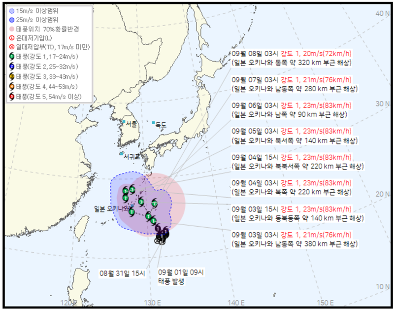
[Financial News Jeju = Reporter Jeong Yong-bok] Typhoon No. 24 KROVANH is forecast to rapidly move northward to the vicinity of Okinawa Prefecture, Japan, before turning westward and heading south again starting on the 4th. Although the currently predicted path does not directly target Jeju Province, a preliminary strong wind advisory is expected for most areas of Jeju Province in the early hours of the 4th due to the strong winds and high waves surrounding the typhoon.
According to the Korean Meteorological Administration and the Jeju Special Self-Governing Province Disaster and Safety Countermeasure Headquarters on the 3rd, at 3 a.m. that day, KROVANH was moving northwest at a speed of 17 km/h in the sea about 380 km southeast of Okinawa Prefecture, Japan.
The center of the typhoon was located at 24.5 degrees north latitude and 130.9 degrees east longitude. The central pressure was 994 hPa, the maximum wind speed was 21 m/s (76 km/h), and the radius of strong winds was 250 km.
The typhoon is expected to strengthen slightly as it rapidly approaches Okinawa Prefecture this afternoon. By 3 p.m., it is projected to have moved to seas approximately 140 km east-northeast of Okinawa Prefecture. The maximum wind speed will reach 23 m/s (83 km/h), the radius of strong winds will expand to 260 km, and the speed of movement will accelerate to 26 km/h.
The point at which the course changes significantly is the 4th.
KROVANH is forecast to move northwest to 28.6 degrees north latitude and 128.1 degrees east longitude by 3 a.m. on the 4th, and then move to 28.4 degrees north latitude and 127.1 degrees east longitude by 3 p.m. on the same day. Its direction of movement is shifting westward, and its speed is expected to slow sharply from 18 km/h in the morning to 8 km/h in the afternoon.
Afterward, at 3 a.m. on the 5th, it will move southward to 27.6 degrees north latitude and 127.1 degrees east longitude. It is expected to move south-southeast on the 6th and east-southeast on the 7th, before changing direction again to north-northeast on the 8th.
Based on the current path, the center of the typhoon will not pass directly over Jeju Province. However, as the typhoon's center trajectory and the affected areas of strong winds and high waves may differ, Jeju Province must monitor changes in land and sea advisories separately.
In a preliminary advisory issued at 4:30 a.m. that day, the Korean Meteorological Administration predicted the possibility of a strong wind advisory being issued for Jeju Province, excluding the southern part of Seogwipo City, from midnight to 6 a.m. on the 4th.
The sea becomes rougher than the land. There is a possibility that a high seas advisory will be issued for the far southern waters off Jeju Province starting on the morning of the 3rd. It is forecast that the advisory will expand to the far southern waters southeast and southwest of Jeju Province by night, and further extend to the waters off Jeju Province by dawn on the 4th.
The Jeju Regional Meteorological Office's short-term forecast also predicts that waves will rise up to 5 meters on the 4th and 5th, mainly in the waters off eastern Jeju Province and the far southern seas. Passenger ships, fishing boats, and coastal fishing vessels traveling between Jeju Province and other regions must check weather advisories before operating.
KROVANH's projected path is still highly volatile.
The 70% probability radius of the typhoon's center, as presented by the Korean Meteorological Administration, expands from 40 km at 3:00 p.m. on the 3rd to 80 km at 3:00 a.m. on the 4th, and then to 110 km at 3:00 p.m. It further expands to 130 km on the 5th, 190 km on the 6th, and 290 km on the 7th, reaching 440 km on the 8th. This means that the farther away the forecast time is, the greater the possibility that the actual location of the typhoon will differ.
Compared with the forecast from the previous day, the expected location during the northward phase has also changed. In its announcement at 4 a.m. on the 2nd, the Korean Meteorological Administration predicted the center of KROVANH at 27.6 degrees north latitude and 129.2 degrees east longitude at 3 a.m. on the 4th, but adjusted it to 28.6 degrees north latitude and 128.1 degrees east longitude a day later. This means the expected location shifted north and west within a single day.
Therefore, at this point, it is important to monitor the possibility of further course adjustments, as the speed of movement around Okinawa Prefecture is slowing and the direction of travel is changing multiple times.
KROVANH is a name submitted by Cambodia and means a type of tree. The Korean Meteorological Administration is scheduled to announce the typhoon's location, intensity, and expected path again around 10 a.m. that day.
The key factor regarding the future impact on Jeju Province is whether KROVANH turns westward as expected in the waters north of Okinawa Prefecture on the 4th, or maintains its southward path thereafter. If the new course is adjusted northward or westward, the distance between Jeju Province and the typhoon could change, so the announcement at 10 a.m. that day is expected to be the next turning point in determining the extent of strong winds and high waves affecting Jeju Province.
[email protected] Jeong Yong-bok Reporter