21 Typhoons Have Formed, but None Have Made Landfall on the Korean Peninsula... Why Has the 'Road to Korea' Not Opened?
- Input
- 2026-08-27 09:29:55
- Updated
- 2026-08-27 09:29:55
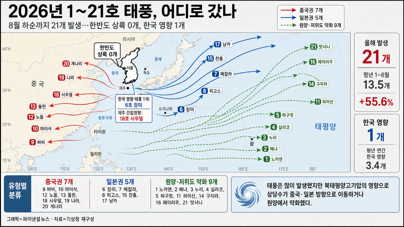
[Financial News, Jeju = Reporter Jung Yong-bok] A total of 21 typhoons formed in the Western North Pacific through late August this year. That is 55.6% more than the average 13.5 storms for the same period, and it already accounts for 83.7% of the annual average of 25.1. Yet not a single typhoon has made landfall on the Korean Peninsula. Officially, the Korean Meteorological Administration has classified only one storm, Typhoon No. 6 Jangmi, as affecting Korea.
The ocean was warm enough to generate typhoons, but a track leading to the Korean Peninsula has rarely formed. It is the paradox of the 2026 typhoon season. This year's storm tracks clearly split toward China, Japan, and the open waters of the Western North Pacific. The pattern appears to reflect the position and edge of the North Pacific High, which helps determine a storm's path, as well as mid-latitude pressure systems that have steered typhoons toward China or Japan rather than Korea.
That said, the fact that typhoons have missed Korea so far does not mean the country is safe through September. If the position of the North Pacific High changes, the route storms take can change as well. In an average September, 5.1 typhoons form in the Western North Pacific.
■ Tracking where this year's 21 typhoons went
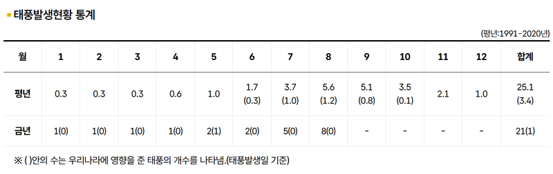
According to typhoon statistics released by the Korean Meteorological Administration on the 27th, 21 typhoons formed from January through August this year. By month, there was one each in January, February, March, and April, two in May, two in June, five in July, and eight in August.
In an average year, 13.5 typhoons form from January to August. This year, the total is 7.5 higher than normal. Compared with the annual average of 25.1, the count had already surpassed 80% before the end of August.
The situation is the opposite when it comes to Korea's exposure. In a typical year, 3.4 typhoons affect Korea, but this year only one storm, Jangmi, has been officially counted.
In the Korean Meteorological Administration's terminology, a 'typhoon affecting Korea' does not necessarily mean a storm made landfall on the Korean Peninsula. Since 2011, the designation has been based on whether typhoon warnings were issued within Korea's typhoon warning zones.
Tropical Storm Jangmi was recorded as this year's first storm to affect Korea when a typhoon warning was issued for the outer waters east of the southern sea on June 2. It did not enter land on the Korean Peninsula, instead passing south of Japan and moving eastward. It did, however, bring swells to Jeju and the southern coast.
Financial News classified the main tracks of Typhoons No. 1 through No. 21 based on data from the Korean Meteorological Administration and the Japan Meteorological Agency. Seven storms moved toward China, five toward Japan, and the remaining nine weakened near the Philippines and the Mariana Islands or followed tracks that took them farther from the Korean Peninsula.
The storms in the China-bound group included Typhoons No. 9 Bavi, No. 10 Maysak, No. 12 Noul, No. 13 Dolphin, No. 18 Saudel, No. 19 Nari, and No. 20 Gaenari. The Japan-bound group included Jangmi, Typhoon No. 7 Mekkhala, No. 8 Higos, No. 15 Chan-hom, and No. 17 Nangka.
Track classification and whether a storm affected Korea are based on different standards. A storm such as Jangmi can be recorded both as moving toward Japan and as a 'typhoon affecting Korea' if it triggers typhoon warnings over Korean waters.
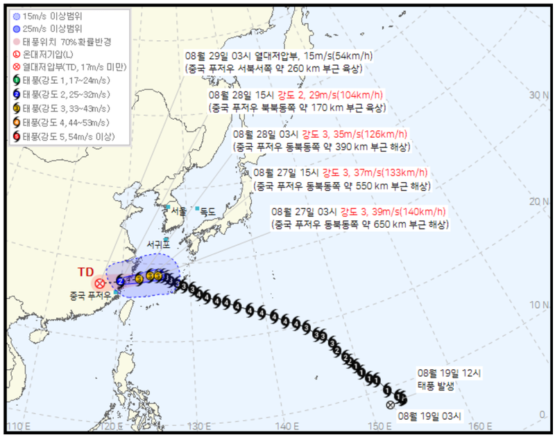
Recent conditions show the same pattern. At 3 a.m. on the 27th, Typhoon No. 18 Saudel was moving westward over waters at 28.5 degrees north and 125.3 degrees east, with a central pressure of 960 hPa and maximum sustained winds of 39 meters per second. The Korean Meteorological Administration said Saudel was expected to cross the East China Sea, move toward China's eastern coast, and weaken into a tropical depression around the 29th.
It had moved up as far as the southern edge of the Korean Peninsula, but instead of turning north toward Jeju or the southern coast, it continued westward.
■ Warm seas fueled typhoons, but high pressure split their paths
The reasons behind the high number of typhoons and the reason they did not come to the Korean Peninsula should be considered separately.
Typhoon formation is influenced by sea surface temperatures, heat stored in the ocean, and atmospheric convection. When Jangmi formed in June, the Korean Meteorological Administration said sea surface temperatures and ocean heat content across the Western North Pacific, including waters around Korea, were above average, creating favorable conditions for tropical depressions to form and intensify.
In fact, typhoon formation was fast from the beginning of the year. By May 21, five storms had already formed, twice the cumulative average of 2.5 at that point.
But where a formed typhoon goes is determined by the surrounding pressure systems. The North Pacific High is the key variable. Typhoons often do not cut directly through the center of a massive high-pressure system; instead, they move along the winds at its edge. Combined with the mid-latitude westerlies and the position of troughs, this determines whether a storm turns west, moves north, or curves east of Japan.
In its summer outlook released in May, the Korean Meteorological Administration also predicted that this year's typhoons would mainly move toward the seas southeast of Japan or near Taiwan.
The key factor cited at the time for Korea's potential exposure was also the North Pacific High. The agency said that if the edge of the high-pressure system sat south of Korea, a typhoon could move north along the East China Sea, and if the high weakened, a storm could affect the Korean Peninsula after passing near Kyushu.
Through late August, however, such a 'route to Korea' never formed consistently. Typhoons moving west were steered toward China, while those turning northeast were diverted toward Japan or the open Pacific.
So it is more accurate to say that the North Pacific High did not block typhoons, but rather that its position and edge created paths toward China and Japan.
■ The pressure pattern that deflected typhoons also intensified the heat
An interesting point is that typhoon tracks and heat waves on the Korean Peninsula are linked to the same summer pressure pattern.
According to the Korean Meteorological Administration's July climate analysis, the North Pacific High gradually expanded from the southeast of Korea in the latter part of the month, bringing mostly clear and hot weather.
The national average temperature in July was 26.8 degrees Celsius, 2.2 degrees above normal and the third highest on record. In particular, the number of tropical nights nationwide reached 9.7 days, the highest since nationwide weather observations were expanded in 1973.
In the southern regions and Jeju Province, clear weather continued under the influence of the North Pacific High, and rainfall was below average. The large-scale pressure pattern that kept typhoons away from the Korean Peninsula also trapped hot air, intensifying tropical nights and heat waves.
Still, typhoon tracks and heat waves should not be viewed as having a single cause. Typhoon paths are shaped not only by the North Pacific High, but also by mid-latitude troughs, the westerlies, and the storm's own location and strength.
The key point is that the same North Pacific High can create heat waves over Korea while also steering typhoons along different routes, depending on how far it extends and where its edge is positioned.
■ An average of 5.1 storms in September... signals can first appear around Jeju's waters
The problem is that typhoon season is not over yet.
Based on 1991-2020 averages, the Korean Meteorological Administration says 5.1 typhoons form in the Western North Pacific in September and 3.5 in October. Roughly one-third of all typhoons in a year form in September and October.
As September begins, the North Pacific High may shrink, its edge may shift, and mid-latitude troughs may move south, creating a different track pattern from the one seen so far. For that reason, it is hard to conclude that typhoon risk is low this year simply because no storm has made landfall through August. Jeju Province, in particular, is a region where typhoon impacts cannot be judged by landfall alone.
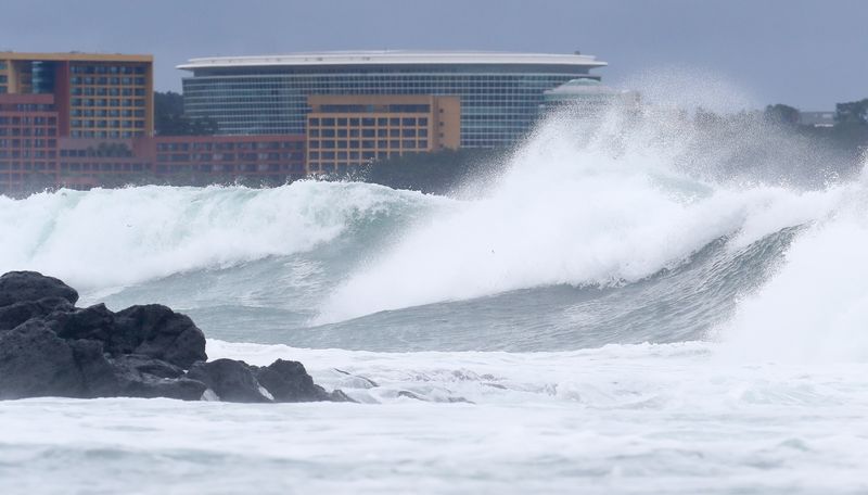
Jangmi did not come ashore on the Korean Peninsula, but it still generated swells along Jeju's coast. Even now, with Saudel not heading toward Jeju, storm warnings remain in effect on the outer waters south and southeast of Jeju Province on the 27th.
That is because even hundreds of kilometers from a typhoon's center, areas can first feel strong winds, swells, high waves, and moisture drawn in from the storm.
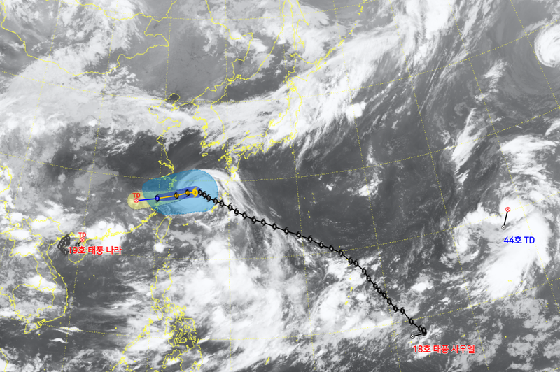
Satellite imagery on the morning of the 27th also showed Saudel moving into the East China Sea while Nari and a new tropical depression were active in the Western North Pacific. The official typhoon count stands at 21, but more storms could still form.
This year's typhoon paradox is clear. The ocean was warm enough to produce storms, and the formation rate was well above average. But so far, no path to the Korean Peninsula has opened.
The remaining typhoon season will not be determined only by how many more storms form. Where the edge of the North Pacific High shifts, and what kind of path the mid-latitude pressure systems create, will be the more direct warning signs for the Korean Peninsula and Jeju Province.
[email protected] Jung Yong-bok Reporter