Three Days of Heavy Rain Bring 813 mm to Geoje; 1 Dead, 159 Evacuated
- Input
- 2026-08-17 13:26:44
- Updated
- 2026-08-17 13:26:44
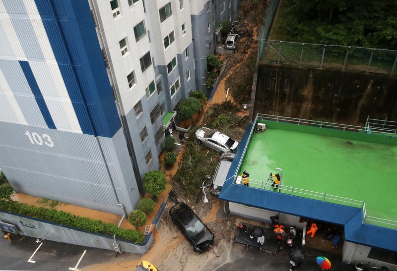
Heavy rain that has fallen on Geoje, South Gyeongsang Province, since the 15th has left 1 person dead and 4 injured after 813 mm of rainfall. In Busan and South Gyeongsang Province, 159 people were evacuated, and 838 reports of damage, including flooded homes and roads, were filed. Up to 60 mm more rain is forecast for the South Coast through the morning of the 18th.
According to a heavy-rain response report from the Central Disaster and Safety Countermeasures Headquarters (CDSCHQ) on the 17th, cumulative rainfall from midnight on the 15th through 10 a.m. that day reached 813.0 mm in Geoje, 685.5 mm in Tongyeong, 437.0 mm in Gangseo-gu, Busan, 375.0 mm in Seogwipo constituency on Jeju, and 360.5 mm in Sacheon, South Gyeongsang Province.
Geoje also recorded the heaviest rainfall. The maximum 60-minute rainfall reached 124.5 mm there. Other readings included 101.5 mm in Gangseo-gu, Busan, 97.4 mm in Tongyeong, 67.5 mm in Seogwipo, 66.4 mm in Jeonnam-Gwangju and Mokpo, and 64.0 mm in Haenam County.
Areas that had been suffering from drought also received significant rainfall. Cumulative totals were 144.7 mm in Uiryeong, 132.0 mm in Miryang, 110.0 mm in Changnyeong County, and 75.5 mm in Cheongdo County, South Gyeongsang Province.
The storm has so far caused 1 confirmed death and 4 injuries. A landslide in Samdoroyal Mansion in Okpo-dong, Geoje, caused casualties. The CDSCHQ has received 838 reports of damage, including flooded homes and roads and fallen trees. The total damage figure may change as field inspections continue.
A total of 159 people from 116 households in six cities and districts in Busan and South Gyeongsang Province temporarily left their homes. Of them, 51 people from 30 households have returned, but 108 people from 86 households have not yet gone back and are staying in private lodging, village halls, or relatives' homes.
Geoje had the largest number of evacuees, with 82 people from 64 households. Sacheon had 41 evacuees from 28 households, and Tongyeong had 17 evacuees from 13 households. In Busan, 9 people in Dong District, 3 in Yeongdo District, and 7 in Saha-gu were evacuated.
Facility restrictions are also continuing. Three vessels on three ferry routes, including Ulleungdo-Liancourt Rocks and Mukho-Ulleungdo, have been suspended. Access has also been restricted to 313 sections across six national parks, including Geumjeongsan and Hallyeohaesang National Park.
A total of 826 areas in six cities and provinces, including riverside walking paths, stepping-stone bridges, and underpasses, have been closed off as dangerous zones. The breakdown includes 397 sites in Jeonnam-Gwangju, 195 in South Gyeongsang Province, 145 in Ulsan, and 48 in Busan. Riverside walking paths account for the largest share at 587 sites, followed by 143 stepping-stone bridges, 28 roads, and 11 underpasses. Flights are operating normally.
A landslide warning has been issued for Geoje, while landslide advisories remain in effect for Goseong County, Gangwon Province; Jinju; Tongyeong; and Changwon in South Gyeongsang Province.
The Ministry of the Interior and Safety raised the heavy-rain crisis alert from 'attention' to 'caution' at 7 a.m. on the 16th and activated CDSCHQ Level 1 at 6 a.m. on the 17th. Minister Yoon Ho-jung held a CDSCHQ meeting at 11 a.m. that day to review resident evacuations and damage recovery efforts.
The Korea Forest Service (KFS) deployed 68 personnel and 32 pieces of equipment to support recovery efforts in Geoje and Tongyeong. The Ministry of Agriculture, Food and Rural Affairs (MAFRA) maintained an emergency response system at its agricultural disaster countermeasures center and sent 883,000 text messages with heavy-rain safety guidelines. The Rural Development Administration (RDA) also activated its Level 1 disaster response center.
[email protected] Lee Bo-mi Reporter