Temperatures surged to 42.5 C... Seoul at 37 C, provinces at 39 C in a suffocating Monday
- Input
- 2026-08-03 04:20:00
- Updated
- 2026-08-03 04:20:00
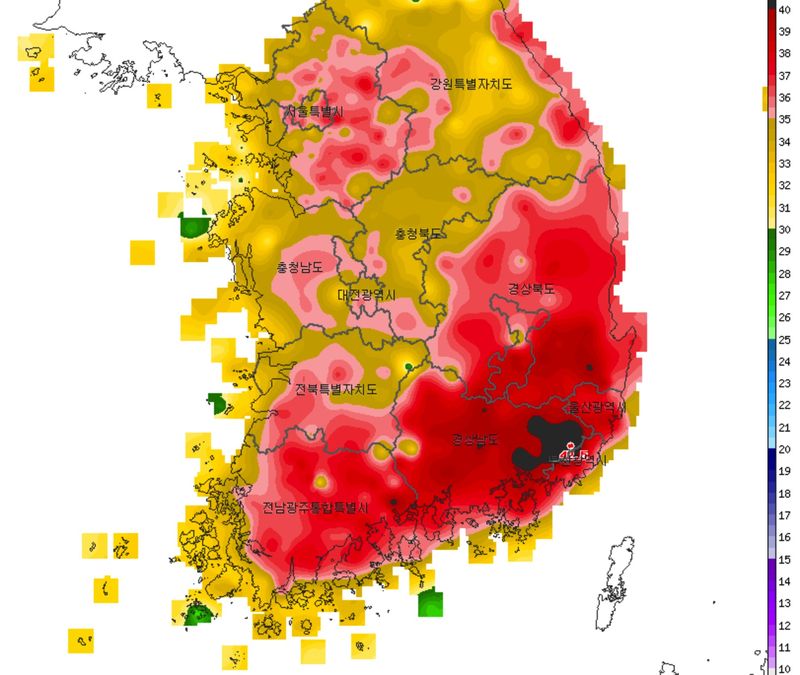
[Financial News] As the record for the highest temperature in the 122-year history of domestic weather observations was broken for the third straight day, extreme heat and tropical nights are expected to grip the country in the early part of this week, which includes the Start of Autumn solar term.
According to the Korea Meteorological Administration (KMA) and automatic weather stations (AWS) on the 2nd, the daytime high in Yangsan, Gyeongsangnam-do, soared to 42.5 C, setting a new record since weather observations began. Extreme heat above 40 C continued across the southern regions, including Miryang at 41.0 C, Gimhae at 40.7 C, Uiryeong at 40.6 C, Gyeongju at 40.3 C, and Jinju at 39.9 C. Busan also climbed to 38.0 C, the highest temperature ever recorded there in August.
Heat wave warnings are currently in effect for 228 of the country's 235 land-based weather advisory zones, or 97 percent of the total. In 24 areas across Jeollanam-do and the Gyeongsang region, including Yangsan, Gimhae, Changwon, Daegu, Gwangju and Suncheon, a severe heat warning has been issued due to health risks.
On Monday, the 3rd, most of the country will be mostly clear or partly cloudy under the influence of the North Pacific High, and the daytime apparent temperature in most areas is expected to rise to around 35 C.
Morning lows on the 3rd will range from 23 C to 27 C, while daytime highs will reach 32 C to 39 C, well above the seasonal norms of 22 C to 25 C for lows and 28 C to 33 C for highs.
Expected morning lows and daytime highs for major cities are: Seoul 26 C/37 C, Incheon 26 C/34 C, Chuncheon 25 C/35 C, Gangneung 26 C/33 C, Daejeon 25 C/37 C, Cheongju 26 C/37 C, Gwangju 26 C/39 C, Daegu 26 C/39 C, Busan 27 C/35 C and Jeju 27 C/34 C. Yangsan, where the heat is especially intense, is forecast to post a morning low of 26 C and a high of 39 C.
Tropical nights, when temperatures do not fall below 25 C overnight, are expected to continue in many parts of the country.
From late afternoon to evening on the 3rd, showers of around 5 to 10 mm may fall in inland southern Gangwon and northern North Chungcheong, but the rainfall will be too light to ease the heat. After the rain stops, higher humidity could make the heat feel even more intense.
Typhoon No. 13, Dolphin (DOLPHIN), which is moving northward northeast of Guam, is increasingly likely to turn west and make landfall in China. If it follows that path, the typhoon is more likely to strengthen low-level westerly winds over the ground and push temperatures even higher west of the Baekdu-daegan, rather than bringing easterly winds that would cool the Korean Peninsula.
Meanwhile, ozone concentrations across most of the country are forecast to reach the "bad" level on the afternoon of the 3rd, while Jeollanam-do and Gyeongsangnam-do are expected to climb to the "very bad" level.
A KMA official urged the public to "immediately suspend or postpone outdoor activities and outdoor work, as the risk of heat-related illness is extremely high, and to take special care of their health by staying hydrated and using cool heat shelters."
[email protected] Moon Young-jin Reporter