National Museum Unfurls 6.7m ‘Daedongyeojido’ Map: “Try Finding Dokdo”
- Input
- 2026-02-26 18:38:01
- Updated
- 2026-02-26 18:38:01
"Was Dokdo originally drawn on the Daedongyeojido?"
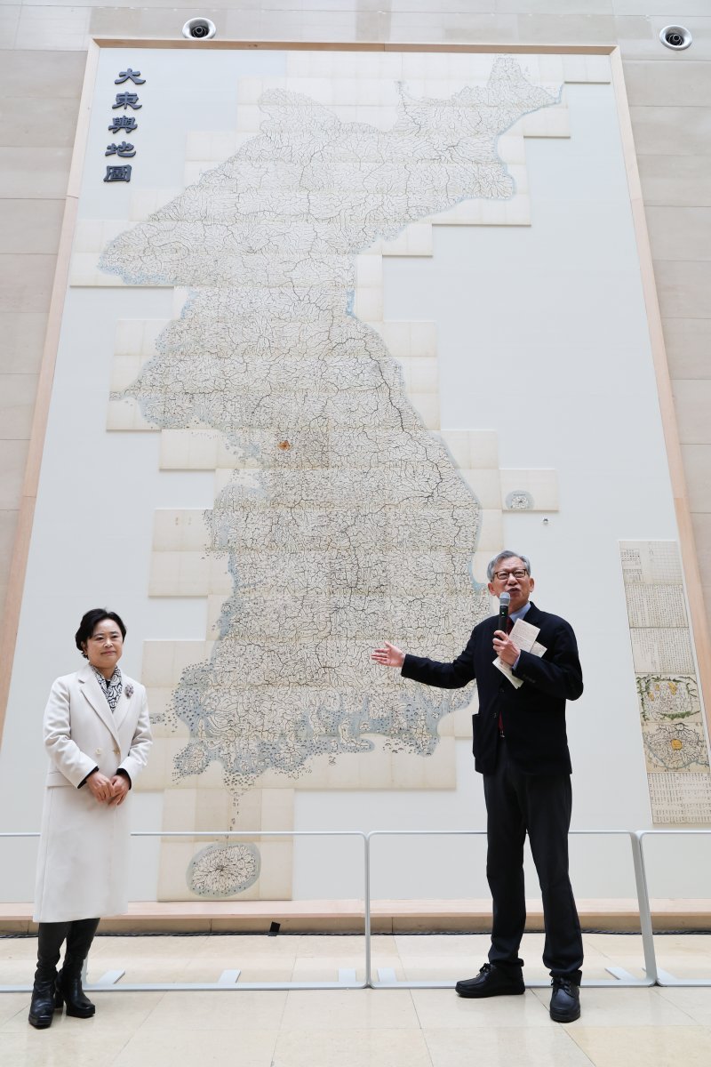
When the entire set of 22 grand panels of the “Daedongyeojido (Great Map of the East)” was spread out in one view, the audience broke into applause and gasps. The Daedongyeojido, completed in 1861 by Gosanja Kim Jeong-ho (1804–1866, approximate dates), greeted visitors in the form of a massive wall map. By linking mountain ranges and waterways like veins, this masterpiece of late Joseon cartography presents the Korean Peninsula at a glance, now displayed vertically across a wall of the National Museum of Korea.
The National Museum of Korea announced on the 26th that it had held an unveiling ceremony on the 12th for a facsimile of the Daedongyeojido in the first-floor Path of History in its permanent exhibition hall, and opened it to the public. The map on display is a large-scale national map measuring about 6.7 meters in height and 3.8 meters in width. Unlike previous permanent displays, which showed only selected sections, this presentation connects all 22 panels into a single, monumental image.
In a typical exhibition, it is difficult to unfold all 22 folded volumes, so visitors cannot easily grasp the map’s true scale. This time, they can appreciate its full extent. The work is installed on the outer wall at the entrance to the Prehistory and Ancient History Gallery, the first gallery in the permanent exhibition area. It is therefore the first object visitors encounter after their belongings are checked. The location marks the beginning of the Path of History, which starts at the Main Hall, passes the digital stele of the Tomb of King Gwanggaeto the Great in the middle of the corridor, and ends at the Ten-story Stone Pagoda from Gyeongcheonsa Temple Site (National Treasure). Due to spatial constraints, the reproduction has been slightly reduced to about 96.5% of the original size.
Lee Jeong-geun, Head of the Archaeology and History Division of the National Museum of Korea, noted, "Old maps are not just records of the geographical information of their time. They also capture how people lived, what worldview they held, and the ideas and values they embraced." He added, "In particular, the Daedongyeojido is not only a crystallization of the mapmaking tradition that flourished in late Joseon and a reflection of the lives and values of Joseon people, but also a representative cultural heritage symbolizing our history and culture, imbued with Gosanja Kim Jeong-ho’s passion for a prosperous nation."
The Daedongyeojido is a woodblock-printed map that divides the Korean Peninsula into 22 north–south strips, each produced as a folding panel (a segmented folding format). When fully opened, it measures about 6.7 meters high and 3.8 meters wide. The museum created a replica by printing high-resolution data of its own copy (accession no. Sin-su 19997) on traditional hanji paper, preserving both the imposing scale and the fine brushwork. Curator Yoo Sae-rom explained, "The map depicts the mountain ranges that begin at Mount Paektu and continue like a backbone, along with the waterways between them, in extremely delicate detail," adding, "Roads are drawn as straight lines, with dots every ten ri to make it easy to calculate distances." Administrative districts, military facilities, walled towns, and beacon mounds are indicated with symbols, while a “map key” at the beginning, equivalent to a modern legend, systematizes the vast geographic information. The “Doseongdo (Map of the Capital),” which portrays Hanyang and its surroundings in the greatest detail, and the “Gyeongjo O-bu Map,” which covers the entire Hanseong-bu and the Seongjeosimni (the area within ten ri of Hanyang’s fortress walls), separately emphasize the capital and clearly reveal the topography and urban structure of Seoul.
In the facsimile unveiled for this exhibition, the name “Dokdo” has been added next to Ulleungdo, even though it does not appear on the original. Uninhabited islets were originally omitted from the Daedongyeojido, so Dokdo was not included, but for this display the museum has inserted Dokdo.
Addressing claims that the Daedongyeojido should be devalued because it does not label Dokdo, Director of the National Museum of Korea Yoo Hong-jun explained, "The Daedongyeojido is a map of the value and form of the land on which we lived at the time, so it did not mark the roughly 2,500 uninhabited islets," and stressed, "It must be understood within its historical context." He went on, "This exhibition offers a chance to confront the Daedongyeojido not just as a bound book but as a vast map in its own right, and to experience firsthand both Kim Jeong-ho’s great achievement and the beauty of our land."
rsunjun@fnnews.com Yoo Seon-jun Reporter