World Heritage Site Faces Flooding Threat 6 Days After Listing.. Water Reaches Beneath Bangudae Petroglyphs
- Input
- 2025-07-18 12:58:24
- Updated
- 2025-07-18 12:58:24
As of 12 PM on the 18th, Sayeon Dam's water level reached 51.6m
Submersion starts at 53m.. Fully submerged at 57m
Weather forecast predicts 120mm of rain by the weekend
Submersion starts at 53m.. Fully submerged at 57m
Weather forecast predicts 120mm of rain by the weekend
【Financial News Ulsan=Choi Su-sang Reporter】 The 'Bangudae Petroglyphs' of the UNESCO World Heritage 'Banguchon Petroglyphs' are facing a flooding threat due to nearly 120mm of heavy rain in the Ulsan area in a single day. This comes just 6 days after its World Heritage listing was confirmed on the 12th.
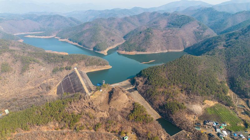
According to the Korea Water Resources Corporation, as of 12 PM on the 18th, the water level of Sayeon Dam has risen to 51.6m. The water level surged as 117mm of heavy rain fell in the areas of Duseo-myeon and Dudong-myeon in Ulju-gun the previous day.
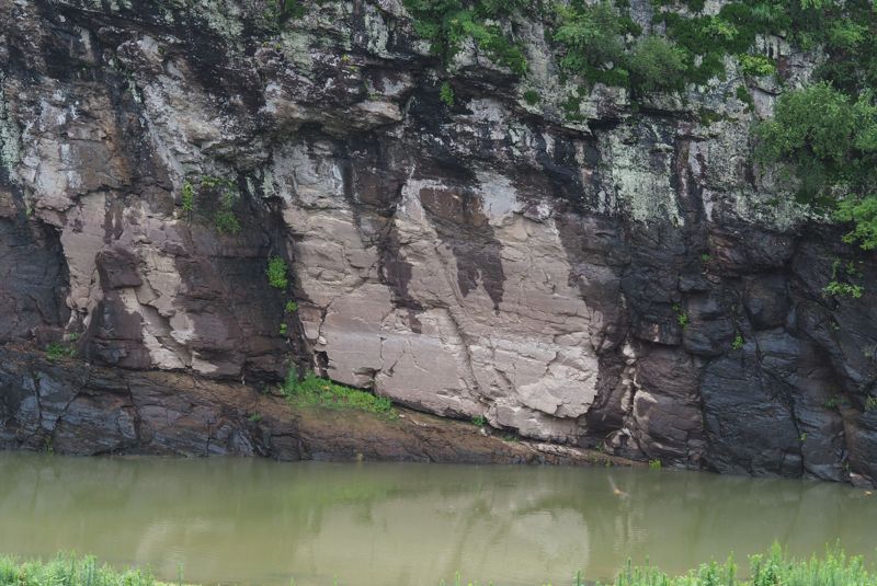
The Bangudae Petroglyphs are located about 3.1km upstream from Sayeon Dam in Daegokcheon (Banguchon). The full water level of Sayeon Dam is 60m, and submersion of the lower part of the Bangudae Petroglyphs begins at 53m, with complete submersion at 57m.
Although the water level of Sayeon Dam showed a continuous rise last night, fortunately, since the morning of this day, the rain in the Ulsan area has subsided, providing some relief. However, the water level continues to rise steadily, albeit at a slower pace.
The flooding status of the Bangudae Petroglyphs is expected to depend on the amount of rain falling from 5 PM on this day until noon on the 19th.
The Korea Meteorological Administration has forecasted nearly 120mm of rain in the upstream areas of Sayeon Dam, including Duseo-myeon and Dudong-myeon in Ulju-gun.
Despite the heavy rain, the Korea Water Resources Corporation maintained the maximum discharge rate of Sayeon Dam, but the inflow was too great to manage. Although there is concern about the damage to the World Heritage site, neither the Water Resources Corporation nor the responsible Ulsan City and Ulju-gun have any effective measures other than waiting for the dam's water level to decrease.
To prevent repeated flooding and damage, a project to install three gates on the Sayeon Dam spillway is underway. The detailed design is in progress, and completion is expected by 2030. Once the gates are installed, the full water level of Sayeon Dam can be lowered to 52m. ulsan@fnnews.com Choi Su-sang Reporter